Tuesday, August 18, 2015

Tuesday, July 21, 2015
Status of Springs and Streams
Many of you may be interested in hiking in the "upland" trails in the King Range (King Crest Trail, Cooskie Creek Trail, Rattlesnake Ridge, etc).
What you need to know is that there are limited water sources once you leave the beach on the Lost Coast Trail. With the drought, many of the upland water sources are at a lower flow compared to what they would normally be at this time of year.


What you need to know is that there are limited water sources once you leave the beach on the Lost Coast Trail. With the drought, many of the upland water sources are at a lower flow compared to what they would normally be at this time of year.

Maple Camp: (above) low flow; dry
along some stretches of stream bed; shallow pools
Miller Camp: Water difficult to find. When you get to the bottom of the switchbacks, head west for a few minutes and you should be able to find some small pools of water among the rocks.
Bonus Spring (on the Miller Camp loop): DRY

Nick's Camp: (above) Abundant; you should have no problem finding water in this small stream

Bear Hollow Spring: (above) Slow trickle; small pool of water ~ 3" deep.

Telegraph Spring: 10/11/2015: Flowing @ 10 min/Liter
More information as it comes in but that's the info as of now. Be sure to bring plenty of water if you are hiking on the upland trails - it's hot up there.
Wednesday, July 8, 2015
Campfires Currently Prohibited

Do to the
extremely dry conditions campfires are currently prohibited in the King Range
National Conservation Area outside of developed recreation sites: Mattole,
Honeydew, Wailaki, Nadelos, Horse Mountain, and Tolkan campgrounds.
It is very
DRY and often very windy.
Even if
it’s foggy the vegetation is still very dry. Also, conditions change frequently
and rapidly here on the coast. I very often see the weather change from calm
and foggy to hot and windy in an hour or less.
If you are
backpacking in the King Range Campfires are prohibited
If you see
a fire ring such as this:

This does
not mean you are permitted to have a campfire. The Bureau of Land Management
did not build these rings. We maintain and dismantle these fire rings but never
build them.
Every year
since I’ve been here we have had an escaped campfire or fire started from a
camp stove.
Use extreme
caution with camp stoves – be well away from dry grasses.
The
instructions for the Whisperlite stove Mountain Safety Research says to, “keep
combustibles 4 feet away from all sides.” MORE than 4 feet would be a VERY good
idea, especially in the extremely dry and windy conditions of the Lost Coast.
The NorthCoast Journal published an article on February of 2013 by a backpacker who
accidentally started a fire on the Lost Coast. The article is well written,
eye-opening and very educational. Here is an excerpt:
“Right
then, a gust of wind hit, and this ball of flame took on a life of its own,
jumping maybe 10 feet to my right and landing on a steep bank of dry grass. In
seconds, the entire hillside was a crackling wall of fire. And that's all it
took. It was out of control.”
Also in the
North Coast Journal:
Advice for
Backpackers (Novice and Veteran)
BY BARRY
EVANS
I started
backpacking and camping when I was 13, and I'm now 70. I'm a 57-year wilderness
veteran, Queen Scout (U.K. equivalent of an Eagle Scout), Sierra Club member,
champion of outdoor ethics, and I don't like open wood fires (too dangerous).
So how do I
explain the fact that I burned down almost a square mile of wild grassland? And
what can I say that might help prevent this from happening to anyone else?
1. Think
"fire." When we picked our campsite, I was thinking flat area, water,
beautiful view. In my over-confidence, I barely gave a thought to what should
have been my No. 1 priority: a safe area for a fire, clear of any vegetation.
2. Think
"wind." The wind blows down the Lost Coast hard, which is why everyone
hikes north-to-south. We'd been seduced by the previous half-hour lull, instead
of assuming that the next big gust might be seconds away.
3. Think
"stove safety." Hundreds of safe, non-eventful lightings of our stove
led to a sense of complacency. Stoves are not foolproof. They can leak. Fuel
left in the bowl does evaporate -- fast, as we found out. A Coleman-fuel stove
like ours sometimes blows out in wind. If it does, it should be allowed to cool
before re-lighting, to prevent flare-ups.
--------------------------------------------------------------------------------------------------------------------------
There have been many escaped campfire or fires started from camp stoves the past several years.
See
pictures below of these incidences:

Photo courtesy of Barry Evans and Louisa Rogers
Spanish Flat, escaped camp stove

Spanish Flat, escaped campfire
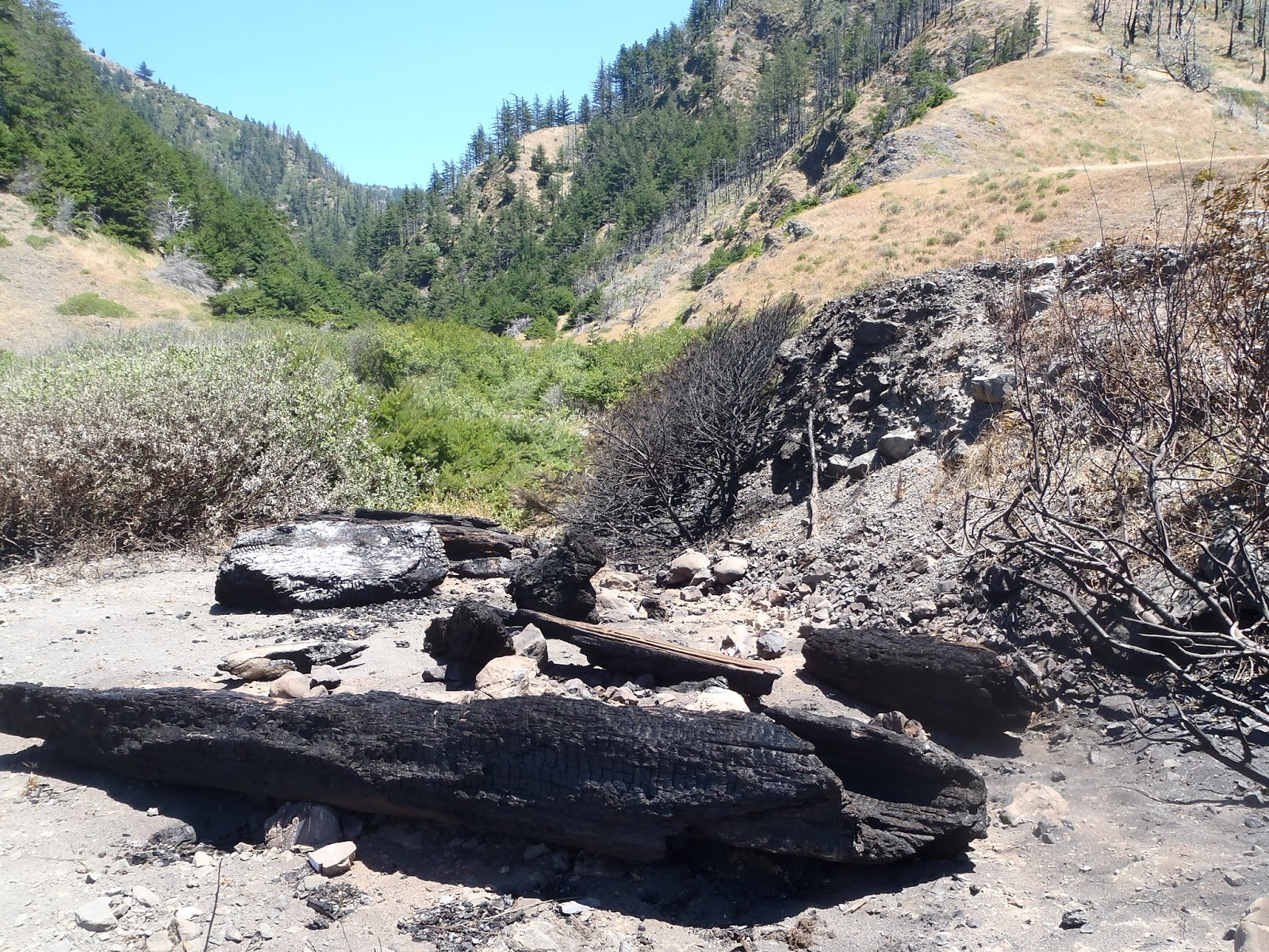
Kinsey Creek, escaped campfire

Cooskie Creek, escaped campfire

Spanish Flat, escaped campfire;
The high winds threw a small ember into a large structure of driftwood, igniting it nearly instantly.

Cooskie Creek, escaped campfire;
It was fortunate that this did not catch the adjacent hillside on fire
If you have questions don't hesitate to contact me
(give at least a few days for a response)
Your Wilderness Ranger,
Paul
707-986-5405
lostcoastranger@gmail.com
Thursday, June 11, 2015
Fascinating Creatures of the King Range #2
This past week while out on patrol of the King Range Wilderness I witnessed quite the spectacle. What appeared to be a large fly/wasp was carrying a caterpillar underneath it as it scurried along the ground next to where I was eating lunch. It eventually reached a small hole in the ground where it dragged the caterpillar down into. The insect came back out empty handed then proceeded to shovel soil and debris into the hole to cover it up - much in the way a dog would cover it's bone.
I have no idea what this insect was so I contacted an entomologist named Eric who identified it as:
"cutworm hunter wasp in the genus Podalonia, family Sphecidae"
Eric also says of the cutworm hunter wasp:
"Cutworm wasps are named for the habit of the solitary females to hunt for soil-dwelling caterpillars (“cutworms”), paralyze them, and store them as food for the wasp’s offspring. The wasp digs her burrow after she procures the prey, which is the opposite behavior sequence of most wasps in the Sphecidae family. Only one caterpillar goes in the bottom of each burrow, and a single egg is laid upon it. The opening of the tunnel is then sealed and the wasp begins seeking another victim to repeat the process."
So There you have it! Very fascinating.
For more about Eric and insects visit his blog at:
http://bugeric.blogspot.com/2011/06/wasp-wednesday-podalonia.html
On another note, I was at the Punta Gorda Lighthouse this past week and noticed some new graffiti and trash left from visitors.

I have no idea what this insect was so I contacted an entomologist named Eric who identified it as:
"cutworm hunter wasp in the genus Podalonia, family Sphecidae"
Eric also says of the cutworm hunter wasp:
"Cutworm wasps are named for the habit of the solitary females to hunt for soil-dwelling caterpillars (“cutworms”), paralyze them, and store them as food for the wasp’s offspring. The wasp digs her burrow after she procures the prey, which is the opposite behavior sequence of most wasps in the Sphecidae family. Only one caterpillar goes in the bottom of each burrow, and a single egg is laid upon it. The opening of the tunnel is then sealed and the wasp begins seeking another victim to repeat the process."
So There you have it! Very fascinating.
For more about Eric and insects visit his blog at:
http://bugeric.blogspot.com/2011/06/wasp-wednesday-podalonia.html
On another note, I was at the Punta Gorda Lighthouse this past week and noticed some new graffiti and trash left from visitors.

The graffiti says, "Evarything is still good! Don't want to bring back coffee cream sugar and TP."
Not only did this individual litter but they also graffitied a historic building. Please, pack out all of your trash and leave your graffiti out of the wilderness. YOU ARE NOT DOING A PUBLIC SERVICE BY LEAVING YOUR UNUSED ITEMS (aka, littering).
A sad sight. And yes, they spelled everything wrong.
Wednesday, May 27, 2015
American Hiking Society and Wilderness Volunteers Visit the King Range
From May 4th-8th six individuals with the American Hiking Society, a national organization that organizes and coordinates volunteer vacations on public lands, joined me on the Lost Coast Trail to perform campsite and trail maintenance, and to restore wilderness character.
30 campfire rings maintained (cleaned of all ash and trash, and made smaller)
35 campfire rings destroyed (removed fire ring and rehabilitated impacts)
4 driftwood shelters destroyed
153 pounds of marine garbage removed
10 pounds of visitor garbage removed
300 feet of trail rerouted away from steep cliffs (~ 1 mile north of Big Flat Creek)
4 piles of toilet paper buried
1 exposed human waste buried

a) Campfire ring before

a) Campfire ring after

b) campfire ring before

b) campfire ring during maintenance

b) campfire ring after maintenance
Please, whenever possible, use existing fire rings. We ask that you use existing fire rings and keep the fire small by using only small pieces of wood that you can break by hand. This helps contain the fire in the ring and also helps to keep the campsites clean for other visitors. Larger pieces of wood tend to spread ash outside of the ring and breaks down its perimeter. In turn, this leads to an eye sore for other visitors and encourages them to build another fire ring - multiplying the impacts.
PLEASE help your friendly ranger by keeping your campfires small (if it's not warm enough just get closer!!) and contained withing the ring. Also, this will keep the area looking natural and undamaged for other visitors.


what used to be the monstrosity in the above photo...

Now looks like this!
This is the most undeveloped and natural I have ever seen this site. A huge success for restoration of wilderness character. The entire section of the Lost Coast Trail that the BLM manages is within designated wilderness. Wilderness areas have very specific mandates that must be managed for: untrammeled, natural, undeveloped, and solitude or primitive and unconfined recreation, in addition they may have unique supplemental or other features.
I admit, when I first hiked the Lost Coast Trail I thought these structures were fascinating. But, the more I learned about wilderness and Leave No Trace the more I understood that these structures are really not that great and actually a nuisance. Let me explain:
- Driftwood structures don’t fit with wilderness characteristics that we manage for. Section 2(c) of the 1964 Wilderness Act states that:
" A wilderness, in contrast with those areas where man and his own works dominate the landscape, is hereby recognized as an area where the earth and its community of life are untrammeled by man, where man himself is a visitor who does not remain. An area of wilderness is further defined to mean in this Act an area of undeveloped Federal land retaining its primeval character and influence, without permanent improvements or human habitation, which is protected and managed so as to preserve its natural conditions and which
(1) generally appears to have been affected primarily by the forces of nature, with the imprint
of man's work substantially unnoticeable…”
- Leave No Trace teaches:
Leave What You Find
- Preserve the past: examine, but do not touch cultural or historic structures and artifacts.
- Leave rocks, plants and other natural objects as you find them.
- Avoid introducing or transporting non-native species.
- Do not build structures, furniture, or dig trenches.
Additionally:
- Wood structures are great habitat for small rodents, especially structures that bring in a new supply of food every night. The one time I stayed in an established structure I had rodents scurrying all over my gear and sometimes me! Also, keep in mind that rodents attract snakes.
- Large structures made out of dry wood are a fire hazard. We have had numerous incidents of driftwood structures catching on fire. This poses a threat to the forest, adjacent land owners, other visitors and YOU. Heavy winds, dry and densely packed fuels and fire are a recipe for disaster. It’s pretty easy for an ember to blow into the cracks of one of a driftwood structure and turn the whole thing into a ball of flames within minutes.
Below is a picture of a driftwood structure that caught fire. A father and his son were staying in it on a windy night, a tiny ember flew off of their fire and into the cracks of the driftwood. According to them, the entire structure was engulfed with flames in only a few moments.

It just so happened that I was camped nearby with a Leave No Trace class; One of our classmates saw the flames as he went out to the beach to brush his teeth. We spent the next 3 hours throwing bear canisters full of water onto the flames to keep it from lighting up the nearby grasses and driftwood.

I understand that it can get very windy out on the Lost Coast..if you make a wind break I ask you to please keep it small, don’t build onto existing structures, and PLEASE restore the site to its original condition by taking the drift wood back to where you found it. It is very easy for a small wind break to turn into a scene from Gilligan’s Island or Lord of the Flies as each visitor that camps at it builds a little more in an attempt to make some kind of “improvement.” Better yet, find a way to deal with the wind without manipulating the site and degrading the wilderness.
Now, where was I...

Hauling nearly 100 pounds of marine garbage

The site of a development, before we restored it to a more natural condition

The site after restoration
From April 19-25, seven individuals with Wilderness Volunteers, a non-profit organization created to organize and promote volunteer service to America's wild lands, joined me in the King Range to perform trail maintenance on Horse Mountain Creek Trail and undertake projects to restore wilderness character.
4.2 miles of trail brushed (cut back of encroaching vegetation)
4.2 miles of trail logged-out (trees and branches across the trail have been removed)
25' of galvanized metal culvert pipe removed and carried out for discard.
2 stream crossing improvements
726 feet of trail tread repair
390 feet of wire fence removed; 16 t-posts and 5 wooden posts
30 pounds of marine garbage removed from the beach
15 pounds of abandoned property removed
3 water bars installed

Brushing.

Brushing..

Brushing...

and more brushing! What a great crew to work with with positive attitudes the whole time!

Before

After

Removing the old culvert

.. and hauling it piece by piece 2 miles out to the trailhead
Just a small sample of the work that was accomplished by these amazing volunteers with AHS and WV for you and our public lands.
Your Wilderness Ranger
Paul Sever
707-986-5405
lostcoastranger@gmail.com
Thursday, April 9, 2015
What's Blooming? Guest Post From The Lost Coast Interpretive Association

Wildflowers are blooming in the high elevations of the King Range. They are spectacular and so are the views! These plants love the rocky, well-drained soil that is characteristic of the King Range. One great place to find them is just down the western slope from the top of Queen Peak (about 2 miles up Paradise Ridge Road). While you’re there, don’t forget to look up! From Queen Peak you can see King Peak, Big Flat and the mountains to the east.
California blue blossom, a low growing species of Ceanothus, steals the show with its clusters of tiny dark blue flowers. Coast whitethorn, another species of Ceanothus, is just starting to show its creamy white flowers. Both shrubs are abuzz with insects busily pollinating the flowers.
Also blooming is monkeyflower with its orange blooms.
Blue witch, a relative of potatos and tomatos, has light purple flowers and yellow centers.
Also thriving is California milkwort, a small delicate looking plant that has deep pink flowers, and yerba santa with its pale purple flowers.


Friday, March 20, 2015
This Week In The King Range: Trail Conditions and Other News
Are you planning to visit the King Range this spring break? Check out this blog post for a ton of useful information.
This past week I hiked from Lightning Trailhead along the King Crest Trail to Rattlesnake Ridge Trail which I descended to Big and Miller Flats; from there I hiked out to Black Sands Beach. Although windy, it was warm and sunny most of the time. These are a few of the things I discovered:
This past week I hiked from Lightning Trailhead along the King Crest Trail to Rattlesnake Ridge Trail which I descended to Big and Miller Flats; from there I hiked out to Black Sands Beach. Although windy, it was warm and sunny most of the time. These are a few of the things I discovered:
1. Along Big Flat
Creek I was lucky to see this Northwestern Salamander:

Do you see it? Look a little closer:

2. Trail Conditions: This is
what you can currently expect on the trails in the King Range
- There are lots trees down on most of the upland trails – This is what Rattlesnake Ridge Trail looks like in several sections:

It is passable
on foot but makes travel more difficult at times.
- The lower portion of Rattlesnake Ridge Trail, where is meanders along Big Flat Creek, can be hard to follow at times. The trail crosses the creek 4 times - Keep an eye out for cairns on each side of the creek crossings to help you find the trail.

FYI - the photo above is not current. I'm including it here to show you what a cairn looks like so you know what to look for. Also, please do not build additional cairns.
- Many sections of the upland trails are dense with vegetation..
.JPG)
Particularly, the King Crest Trail, the top half of Buck Creek Trail and the top half of Rattle Snake Ridge Trail.
- Cooskie Creek Trail can be VERY difficult to navigate because the trail goes through a lot of grass, it doesn’t receive a lot of traffic, and there are wildlife trails (and cattle trails in some areas) that go on/over/adjacent to the real trail. It would very much benefit you to have route finding skills.


- The Lost Coast Trail is rocky and sandy – you will probably not be going much faster than about 2 miles per hour. Many people tell me that the trail is much more difficult than they expected.

(Photo by Daniel Hartmann)
3. I packed
out close to 2 pounds of garbage between Big/Miller Flats and Black Sands
Beach. This is garbage left behind by backpackers! I know how easy it can be to
accidentally leave behind a wrapper – It’s good to get into the habit of
checking around your campsites, resting areas, lunch spots, etc., before you
leave. Once I get my pack on I always take a few steps then turn back around
and scan the site. You never know – this has saved me from not only forgetting
trash but also cameras, knives, and hats!

As always, feel free to contact me if you have any questions. There's a possibility that I may be out on the trail so give me a few days to get back to you. If you need immediate assistance call 707-986-5400.
Your Wilderness Ranger,
Paul Sever
Lostcoastranger@gmail.com
707-986-5405
Subscribe to:
Posts (Atom)