Monday, July 9, 2012

Active Bears and Current Fire Restrictions

BREAKING NEWS: The bears in the King Range are active and hungry. This past week we have had numerous bear incidences involving food.

In one case it was reported that a bear came into a camp while the occupants were awake and was able to obtain some amount of food because the canisters were not fully secured. In another case this past week a camper put his canister inside of his backpack and hung it in a tree – the backpack was damaged in the bears attempt to reach the food. It’s safe to store your items just inside of your backpack while you are actively using them – during the day as you are traveling. However, when you reach camp or are away from your items for any amount of time you need to securely store them in your canister.

Today I’m talking with a fellow hiker, Mike, who has some questions and comments regarding bears and proper food storage here in the King Range.


What kind of items need to be stored in the canister? A bear can’t smell my freeze dried food, right?

You need to store all of your food and scented items in the bear canister. This includes cans and freeze dried foods as well as your toiletries such as toothpaste and sunscreen. Your trash still carries scent so put that back in the can too (the cans we rent come with a small trash bag). Hanging your food is not an option in the King Range and on the Lost Coast Trail.

Bears have an extremely heightened sense of smell. According to the American Black Bear Association:

There is perhaps no other animal with a keener sense of smell. Bears rely on their sense of smell to locate mates, detect and avoid danger in the form of other bears and humans, identify cubs, and FIND FOOD. Although the region of the brain devoted to the sense of smell is average in size, the area of nasal mucous membrane in a bear's head is one hundred times larger than in a human's. This gives a bear a sense of smell that is 7 times greater than a bloodhound's.

I mean, I don’t mind if I lose some food to a bear. Besides, I can just cut my trip early…

The bear can is for protecting the bear from your food not for protecting your food from the bear. You will notice on top of the Garcia Backpackers’ Cache it says, “Save the bears” (it does not say, “Save your food”). So, what does this mean? When a bear starts to eat human food and learns that humans can be associated with an easy meal they will lose their fear of humans, come around campsites more often, and become increasingly aggressive. This is what you would call a “habituated” or “food conditioned” bear and they could eventually need to be put down if the aggression gets out of hand.

UNDER ABSOULTELY NO CIRCUMSTANCE SHOULD YOU EVER FEED A BEAR.

Let me rephrase that,

NEVER FEED A BEAR.

Where can I get a bear can?

We rent out the Garcia bear can here at the BLM Project Office in Whitethorn for $5 for your entire journey. You will need a credit card and a drivers licensed (if you don’t return the bear can you will buy it). We are open Monday-Friday 8-4:30. If your trip ends after our closing hours you can drop your can off in the afterhours bear can return box next to our building. Keep in mind that our front gate will be closed but you can still walk in.

You can also rent from the BLM Field Office in Arcata which has the same hours as the Project office here in Whitethorn: Monday-Friday 8-4:30.

You can also rent from:

Shelter Cove General Store
7272 Shelter Cove Rd. Whitethorn
707-986-7733

Petrolia General Store
707-629-3455

HSU Center Activities
707-826-3357

Additionally, we will be going into full campfire restrictions in the King Range starting July 1st. The news release reads:

Effective July 1, the Bureau of Land Management is implementing fire restrictions for lands managed by the Arcata Field Office in Humboldt, Del Norte, Trinity and Mendocino counties.  The restrictions will remain in effect until further notice.
                Field Office Manager Lynda Roush said the restrictions are needed because of dry fuels and increasing fire danger in the North Coast region.  She said wildfires under these conditions can pose threats to public land visitors, natural resources and adjacent private lands and communities.
                Under the restrictions, all campfires and barbecues are prohibited except in specifically posted campgrounds and recreation sites.  Portable stoves and lanterns using gas, jellied petroleum or pressurized liquid fuel are allowed outside of posted recreation sites, with a valid California campfire permit.  The public is asked to be extremely careful with their use and to carry a shovel and water at all times.

So, please refrain from having a campfire in the King Range due to the extremely dry conditions. Also, please be very careful with your portable stoves. Last year we had over 400 acres burn near Spanish Flat due to a portable stove catching the grass on fire.

Thursday, May 24, 2012

American Hiking Society and New Rangers


This month from the 7th-11th Justin Robbins (Outdoor Recreation Planner here in the King Range) and I had the pleasure of working with 8 great volunteers from the American Hiking Society. They worked hard on the Lost Coast Trail and I hope you’ll appreciate the time and energy they put into our public lands. 


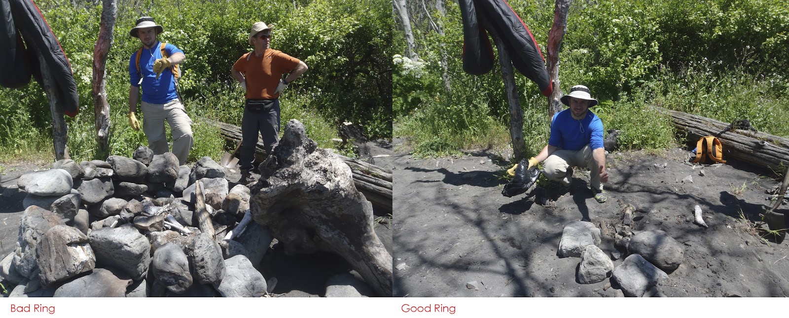
One of many things we did was clean/dismantle fire rings. As you can see in the pictures below, fire rings have a tendency to get out of hand. 


If you have a campfire, please help maintain “good rings” and fire safety:

1. Use existing fire rings and keep your campfire small. There is no need to build a gargantuan fire ring. If you need more warmth then simply get closer to your fire. Building large fire rings encourages the burning of larger pieces of wood and this tends to spread ash outside of the ring and breaks down its perimeter. This leads to an eye sore for other visitors and encourages them to build another fire ring - multiplying the impacts.

2. If it’s too windy and there are dry grasses or piles of driftwood nearby you may want to reassess your need for a campfire that night. Please don’t try to make the area “safe” by destroying vegetation or digging into the ground. This will most likely make the camp unsightly for other visitors. If the scene is safe, be sure to always have someone present to watch over/tend the fire and have plenty of water nearby to extinguish any rogue flames.

3. Please pack out your trash and do not burn it in your campfire unless it can be completely burned in one sitting and you plan to do so. Examples of things that often do not burn completely in one sitting: Anything lined in foil (e.g. Mountain House packaging), metal cans, plastics, and food scraps (e.g. orange peels, egg shells).

4. Use dead and downed wood. Collect wood that can be broken by hand to help keep the campfire small and reduce your impacts.

5. To extinguish your campfire soak it with plenty of water and stir. Smothering with sand doesn’t put the fire out completely and when the wind picks up it blows the sand off leaving a potentially hazardous situation. Also, this fills the ring with sand which in time makes the ring undesirable/unusable and encourages others to build new campfire rings – spreading the impact.

In addition to campfire ring maintenance we also:

Collected A LOT of beach garbage. The picture below is just a sample of what we collected.

These guys were some true beachcombers.

We pulled non-native species, such as European Beach Grass. 


We brushed and lopped several sections of the trail


We dismantled user created structures/shelters


We’ve been taking down the driftwood structures along the LCT the past few years and it’s looking good. In past years you would see huge elaborate structures at nearly every creek – but no longer. You may ask, “what’s the problem with these anyhow,” and I’ll tell you:

  • Wood structures are great habitat for small rodents, especially structures that bring in a new supply of food every night. The one time I stayed in an established structure I had rodents scurrying all over my gear and sometimes me! Also, keep in mind that rodents attract snakes.
  • Large structures made out of dry wood are a fire hazard. We have had numerous incidents of driftwood structures catching on fire. This poses a threat to the forest, adjacent land owners, other visitors and YOU. Heavy winds (forecasted for this weekend), dry/dense fuels and fire are a recipe for disaster. It’s pretty easy for an ember to blow into the cracks of one of a driftwood structure and turn the whole thing into a ball of flames within minutes.
  • Driftwood structures don’t fit with wilderness characteristics that we manage for or Leave No Trace ethics. Section 2(c) of the 1964 Wilderness Act states that:                                                             
" A wilderness, in contrast with those areas where man and his own works dominate the landscape, is hereby recognized as an area where the earth and its community of life are untrammeled by man, where man himself is a visitor who does not remain. An area of wilderness is further defined to mean in this Act an area of undeveloped Federal land retaining its primeval character and influence, without permanent improvements or human habitation, which is protected and managed so as to preserve its natural conditions and which
(1) generally appears to have been affected primarily by the forces of nature, with the imprint
of man's work substantially unnoticeable…”

I understand that it can get very windy out on the Lost Coast. If you find that you need to build a small structure to escape the wind, ok. But, I ask you to please keep it small, don’t build onto existing structures, and PLEASE restore the site to its original condition by taking the drift wood back to where you found it. It is very easy for a small wind break to turn into a scene from Gilligan’s Island or Lord of the Flies as each visitor that camps at it builds a little more in an attempt to make some kind of “improvement.”

SO, in addition to all the great work the volunteers from the American Hiking Society did, I’m excited to introduce the newest member of our Wilderness Ranger staff, Jamie (photo coming soon). I'll toss the keyboard over to her:

"Hello folks! My name is Jamie and I am your seasonal Wilderness Ranger for the summer. I was born and raised in northern California and am currently finishing up my Environmental Management and Protection degree at Humboldt State University.  When I’m not chatting with lovely visitors like yourself, it’s not uncommon to find me “nerding out” while I hike – attempting to identify different tree species, animal tracks and ocean critters.

I am very excited to spend the next few months in the King Range and to share this natural treasure with all of you. See you out there!”

                               View from Cooskie Spur Trail - by Hilton Cass

Ok, to wrap up this post I would like to remind you that when you need to dispose of solid human waste on the LCT dig a hole 6-8 inches deep in the wet sand below the high tide line (or as close to the wet sand as safely possible), make your deposit, and then cover the hole with sand. The steep and rocky cliffs along the trail and at the major drainages/camping areas make finding a place to go 200 feet away from campsites, trails, and drinking water sources (standard Leave No Trace practice) nearly impossible – therefore, we have found that the ocean is the most ideal place to dispose of human waste.

You may feel a bit bashful about this since it’s out in the open but if you don’t wait until the last minute you can almost always walk down the beach a bit and find some solitude. If for some reason you absolutely can’t go down on the beach, PLEASE at least bury your waste with 6-8 inches of soil  (not just a rock) as far away from campsites, streams and trails as you can possibly get.

It’s going to be a busy weekend out there. Be safe and remember there were people here before you and there will be people here after you. Do the right thing and help keep the Lost Coast clean and enjoyable for everyone.

Your Wilderness Ranger,
Paul Sever
707-986-5405
lostcoastranger@gmail.com

Tuesday, April 10, 2012

Spring: The Season of the Tick

These nasty little creatures feed by attaching and sucking blood from their host. Below is the magnified mouth parts of a tick – amazing (Pictures from the California Department of Public Health).


The King Range is abundant with ticks around the spring and summer months. The main problem with these creatures, besides the fact that they give you the creeps, is that they transmit disease. The western blacklegged tick, Ixodes pacificus, transmits the bacteria that cause Lyme. There was a great article in the North Coast Journal from April 2011 Titled, “Repellant,” that said:

Deer ticks don’t jump or leap onto their hosts; they crawl and “quest” by positioning themselves on leaves or blades of grass, then raising their clawed forelegs. Aided by carbon dioxide sensors on their legs, they anticipate approaching animals and grab onto their furry coats as they pass by. Or, in the case of people, they grab onto pant legs or shirt tails.

Well said, and there are plenty of grasses along many of the trails that serve as great places for ticks to position themselves. Now that you’re aware of this you can take the necessary precautions and actions.


It is recommended that you:


Stay in the middle of the trail and avoid grassy areas, contact with logs, tree trunks and
fallen branches or tree limbs in forests. This may be impossible to avoid on sections of the Lost Coast Trail so check yourself often (hair line, armpit, back
of knees, groin) for ticks during and up to three days after your trip in tick infested areas.

Tuck pants into boots or socks, and shirt into pants.

Wear light-colored clothing and long-sleeved shirts so ticks can be more easily seen.

Use a repellent registered for use against ticks. Repellents with DEET are effective
and can be applied to the skin. Repellents with permethrin should be applied only to
clothing. Always follow directions on the container and be especially careful when
applying to children.


To remove a tick:


Grasp the tick’s mouthparts as close to the skin as possible.


Gently pull the tick straight out, using a firm steady motion.


Wash your hands and the bite site with soap and water. Apply an antiseptic to the
bite site.


Prompt tick removal can prevent transmission of infection because an infected tick must be attached and feeding for at least a day before it can transmit the spirochetes (the bacterium that causes Lyme disease).


Consult with your physician if you develop any symptoms, especially a rash, within
30 days of the tick bite.


According to the California Department of Public Health:

Lyme disease can affect many body systems. Lyme disease can start as a mild flu-like illness and, over time, develop into severe chronic health problems. The early stages of the disease can include a red, expanding skin rash (called erythema migrans or EM), chills and fever, headache, swollen lymph nodes, muscle and joint pain, weakness of some muscles in the face, and heart irregularities. The EM rash appears up to 30 days after the bite of an infected tick. One or more EM rashes can occur, not necessarily at the tick bite. The rash can precede, accompany, or follow flu-like symptoms. The rash may not be noticed in some instances due to skin tone or occurrence on the body in locations difficult to see. Occasionally, an allergic reaction to the tick bite can occur on the skin and may be mistaken for an EM. The allergic reaction is different from an EM rash because it happens within minutes to hours after the tick bite and does not spread. If left untreated, arthritis or nervous system signs can develop in some Lyme disease
patients. Arthritis is most likely to appear as bouts of pain and swelling, usually in one
or more large joints, especially the knees. Nervous system abnormalities can include
numbness, tingling, or pain in the arms and legs, or difficulties in memory and the ability
to concentrate.Lyme disease can be successfully treated with antibiotics, especially in the early stages. The potential for long-term complications increases if the disease progresses untreated.


I don’t think this is something to cancel your trip over but you should definitely be aware and take precautions. Visit the CDPH web page for a wealth of information about tick-born diseases.


Hope this helps,


Give me a call if you have any questions about hiking the Lost Coast.


Your Wilderness Ranger,


Paul


707-986-5405


Thursday, March 8, 2012

Plan To Visit The Lost Coast This Spring Break?

A few things to know and FAQ:

1. Although this winter is quite dry, are we likely to get soaked all week at the end of March? What is the weather like?

Being on the coast the weather can change rapidly. It’s not uncommon for it to go from clear and sunny to windy and rainy in a matter of hours. Be prepared for any and all types of weather conditions. I suggest checking the 14 day precipitation outlook several times leading up to your planned trip dates to get an idea of what may be coming our way.


The picture above is a clip for March 14 from the 14 day precipitation model from NOAA. As of now it is forecasted to be rainy all next week. This is unfortunate for you first wave of spring breakers but keep checking the forecast because you never know - something may change. This brings us to our second FAQ:

2. I heard that streams can become impassable in the spring months, what should I expect?

As of this moment, the streams are very much passable since we have had very little rain this year. However, if these new weather systems move through and dump several inches over the next few weeks you should be ready for difficult stream crossings. With heavy rains the creeks in the King Range can rise rapidly and there is the possibility that they will be impassable within a day or several hours of an intense down pour. However, this also means that streams may recede to a safe crossing level within a day or several hours after it has stopped raining. Of course, this depends on how long and heavy it has been raining for. Have a backup plan to turn back, wait it out, or take an upland trail (which will add considerable mileage and time to your trip). General rule of thumb says not to attempt a creek crossing if it is deeper than your knees. You’ll need to assess your own skills/level of confidence and that of your group when it comes to deep and swift moving creeks.

3. There are sections of trail that are impassible at high tide, right?


That's correct. There 4 “impassable during high tide” sections on the trail:

1. Punta Gorda (I personally have not had trouble passing this spot unless it is a very high tide and/or swell)

2. Sea Lion Gulch to Randall Creek

3. Miller Flat to about one mile south of Buck Creek

4. South of Shelter Cove is Point No Pass. This is impassable at ALL tide levels. Do Not Attempt. If you plan to hike from Shelter Cove to the Sinkyone Wilderness State Park catch the Lost Coast Trail at Hidden Valley. The trailhead is on Chemise Mountain Road, off of Shelter Cove Road.

How high of a tide is too high to pass? It’s difficult to say exactly but, all other factors aside, somewhere between 3.5 to 4.5 feet. Watch the ocean condition predictions, especially during the winter months, because large waves can impede and make travel potentially dangerous - even during low tides.

Also, know that during high tide you can be camped at the major creeks (named on the map) that are in the middle of the “impassable at high tide” zones because the creek mouths give you plenty of space to move up off the beach.


Click here for a tide chart.


3. Is there a permit process? Why?

Currently, we have free self-service permits that you can pick up at any of the trailheads or at our office in Whitethorn (768 Shelter Cove Road). Please take a few moments before your trip to fill one out AND read it over front to back with ALL members of your party. The backcountry permit serves multiple purposes. On one hand, it is a way for us to keep records of how many people are out there recreating so we can better manage the King Range. It is also a tool to locate lost/missing hikers. For example, if we notice a vehicle has been sitting at a trailhead for an unusual amount of time we can try to find a permit with a matching licensed plate number. Based on what they indicated on their permit we can determine how many people are in their group, where they planned to go, and when they planned to come out of the backcountry (this information also helps to calm worried family members who occasionally call our office – it’s a good practice to tell someone where you’re going and the details of your plans).

For the King Range, this backcountry permit also serves as your campfire permit. When you sign the permit you,

“…agree to follow the guidelines for overnight camping in the King Range backcountry, especially regarding the use of bear-proof canisters, backcountry sanitation, and the use of fire.”

The permit serves as a way to get essential information to you and to ultimately reduce impacts to the fragile backcountry environment. Which brings us to our next topic:

4. I heard there are bears in the King Range. Can I hang my food or do I need a bear canister?


Bears are very real here in the King Range. People are often surprised that bears will come all the way down to the beach. But indeed, just about every morning I’m out on the trail I see bear tracks in the sand.


All overnight visitors must store all of their food, toiletries and scented items (Including trash!) in a hard-sided bear-proof container approved by the Sierra Interagency Black Bear Group (SIBBG). Hanging your food is not an option in the King Range and on the Lost Coast Trail. You may be experienced with hanging food but there is a serious lack of sufficient trees on the LCT. Requirements for hanging food vary from place to place but generally 10’ high and 4’ from the base of the tree would be sufficient. You are not going to be able to achieve this on the LCT.

The bear can is to protect the bears from your food and the extra bonus is that you also protect your food from the bears. You will notice on top of the Garcia Backpackers’ Cache it says, “Save the bears” (it does not say, “Save your food”). So, what does this mean? When a bear starts to eat human food and learns that humans can be associated with an easy meal they will lose their fear of humans, come around campsites more often, and become increasingly aggressive. This is what you would call a “habituated” or “food conditioned” bear and they could eventually need to be put down if the aggression gets out of hand.

We are really lucky here at the King Range that we don’t have any habituated bears. In large part because we initiated the bear can requirement early enough and people have been abiding by the regulation.

We rent out the Garcia bear can here at the BLM Project Office in Whitethorn for $5 for your entire journey. You will need a credit card and a drivers licensed (if you don’t return the bear can you will buy it). We are open Monday-Friday 8-4:30.

Other places to rent cans (call for availability, hours and prices):

BLM Arcata Field Office
1695 Heindon Rd. Arcata
707-825-2300

Shelter Cove General Store
7272 Shelter Cove Rd. Whitethorn
707-986-7733

HSU Center Activities
707-826-3357
http://humboldt.edu/centeractivities/rentalGear.php

Petrolia General Store
707-629-3455

REI also rents bear cans but the pricing varies from store to store so I won’t list it here. They did tell me that it is substantially less expensive for members, however.

Lastly, there is one other animal that the bear can is good for: the raccoon. These little animals are a nuisance as far as your food is concerned. They are very active and will literately tear apart your backpack to get to your food. Do yourself a favor and help protect the animals in the king range by getting a bear can.


5. Can I have a camp fire this time of year?

Campfires are permitted right now. We ask that you use existing fire rings and keep the fire small by using only small pieces of wood no bigger in diameter than the size of your wrist. This helps contain the fire in the ring, helps to keep the campsites clean and reduces fire danger. Larger pieces of wood tend to spread ash outside of the ring and breaks down its perimeter. In turn, this leads to an eye sore for other visitors and encourages them to build another fire ring - multiplying the impacts.Please put your fire out with plenty of water with the soak and stir method. It should be cool to the touch by the time you’re done.

I haven't taken much pictures of campfire rings in perfect condition but we would like to avoid campfire rings that are in the conditions below:


6. I heard there was a unique method of human waste disposal on the LCT, what is that?


When you need to dispose of solid human waste on the LCT dig a hole 6-8 inches deep in the wet sand below the high tide line (or as close to the wet sand as safely possible), make your deposit, and then cover the hole with sand.

There are 4 goals with human waste disposal in the backcountry:

1. Minimize contact with water sources

2. Minimize contact with insects and wildlife

3. Minimize social impacts. This is the disgusting factor when you see a pile of waste right next to where you are camping.

4. Maximize decomposition (when we bury it 6-8 inches it maximizes decomposition by mixing with the soil and microbiological organisms. Putting a 6-8 inch rock on top of it is not burying it).

The steep and rocky cliffs along the trail and at the major drainages/camping areas make finding a place to go 200 feet away from campsites, trails, and drinking water sources (standard Leave No Trace practice) nearly impossible – therefore, we have found that the ocean is the most ideal place to dispose of human waste. If for some reason you absolutely can’t go down to the beach to take care of business PLEASE go at least 200 feet from campsites, trails, and drinking water sources and BURY your waste!

Lastly, to wrap up, please pack out your trash and do not burn trash in your campfire unless it can be completely burned in one sitting and you plan to do so. Examples of things that often do not burn completely in one sitting: Anything lined in foil (e.g. Mountain House packaging), metal cans, plastics, and food scraps.


Trash I pulled out of a campfire ring

I encourage you to visit the Leave-No-Trace Center for Outdoor Ethics website become familiar with their 7 principles.

There are many people that come to enjoy the King Range and the Lost Coast. Help keep the Lost Coast clean and enjoyable for your future visits and for everyone that comes to enjoy this special landscape.


Send me a message or give me a call if you have any questions


Your Wilderness Ranger,


Paul


707-986-5405

Wednesday, March 7, 2012

Sinkyone Road Failure

According to the Times Standard, the Bear Harbor Road between Needle Rock and Bear Harbor is impassible to vehicles but is still open to pedestrain access.

"...Walk-in access to Orchard Camp, Railroad Camp and Bear Harbor Campground will be the only way to visit these areas."

Your Wilderness Ranger,
Paul

Tuesday, February 14, 2012

California Conservation Corps on the Lost Coast


This week, February 13-17, a crew from the California Conservation Corps (CCC) will be out on the Lost Coast pulling Cape Ivy, an invasive plant species. According the the California Invasive Plant Council,


Cape ivy climbs over most other vegetation, forming a solid cover that blocks light and smothers other vegetation. The weight of the ivy mass sometimes causes trees to fall. Habitat for both plants and animals in protected natural reserves has been rendered worthless when large portions are occupied almost exclusively by cape ivy.


We greatly value the hard work the CCC puts into the King Range NCA to help restore Wilderness Characteristics. If you see them out there thank them for what they do.


And on another note, check out some interesting weather we were having.


Your Wilderness Ranger,

Paul


707-986-5405